Import from PostGIS
Overview
Register spatial tables from a connected PostGIS database as datasets in an AcuGIS Cloud Library folder. You can start in the destination folder for a direct workflow or use Wizard to discover and preview tables before choosing the folder.
PostGIS datasets remain linked to their source tables. AcuGIS Cloud does not copy the table into file storage; reads and permitted edits operate on the source database.
Connect before importing
The PostGIS database must already be configured as a Database Service (pg_service.conf entry). If it is not listed during import, follow Connect to PostGIS first.
Before You Begin
- Sign in to an active AcuGIS Cloud account.
- Confirm that you can add datasets to the destination Library folder.
- Have access to a configured PostGIS Database Service.
- Confirm that the database role can connect and has
USAGEon the required schema andSELECTon the spatial tables. - For editable datasets, confirm that the role has only the required write permissions.
- Check that each source table has a geometry column and a correctly assigned spatial reference system.
Changes can affect source data
A registered dataset is a live reference to PostGIS. Edits made through AcuGIS Cloud can change the source table when the database role allows writing. Use a read-only role when users should only view data.
Step-by-Step
Import from a Library folder
Use this workflow when you already know which folder should contain the registered dataset.
1. Open the destination folder
Open My Drive, navigate to the destination Library folder, and click Add Dataset. Select PostGIS Import.
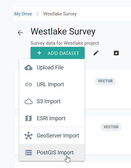
Caption: Starting in a folder fixes the Library destination before you browse the database.
2. Browse a Database Service
The PostGIS Import page lists the configured Database Services and their connection details. Find the service that points to the required database, then click Browse.
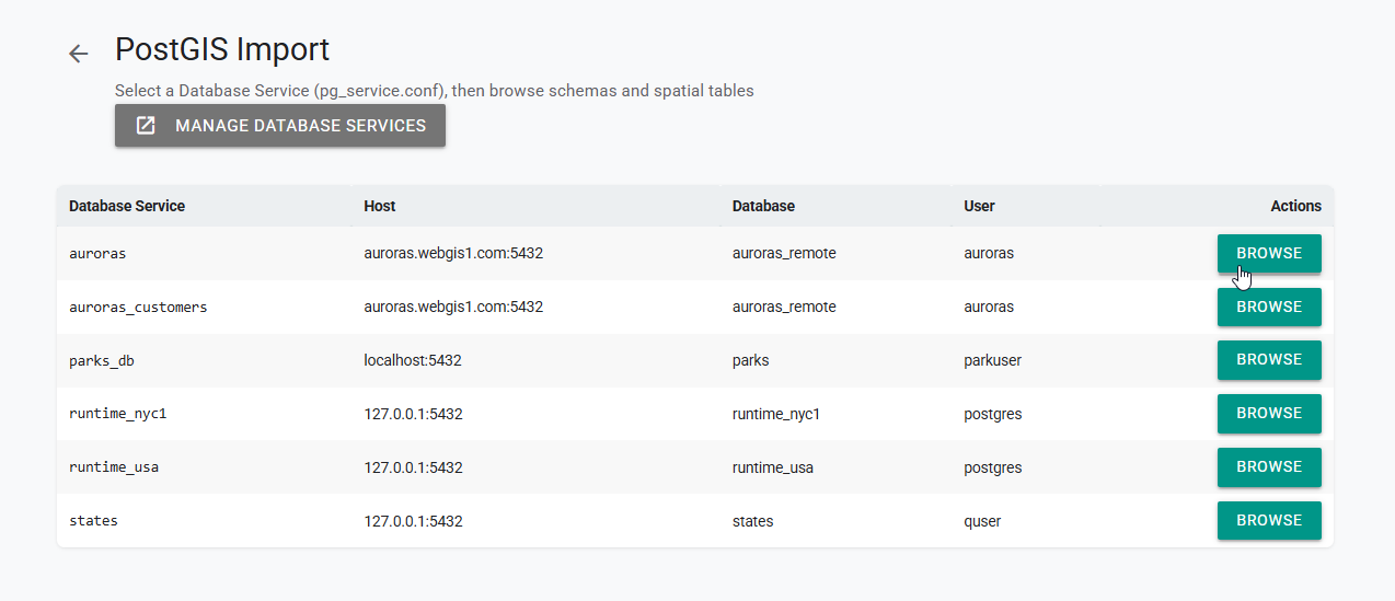
Caption: Browse connects through the selected service and discovers its schemas and spatial tables.
Confirm the database, not just the service name
Review the host, database, and user columns before continuing. Similar service names can point to different environments or provide different permissions.
3. Select a spatial table
Review the discovered Schema, Table, Geometry, SRID, and Type values. Locate the table you want to add, then click Register.
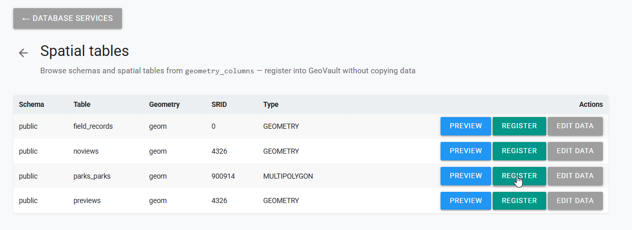
Caption: Register adds a reference to the selected table without copying its data.
The available actions have different purposes:
- Preview — inspect the table before registering it.
- Register — create a dataset reference in the current Library folder.
- Edit Data — open the source table for editing when the connection has sufficient permissions.
Check geometry metadata
Confirm that the geometry type and SRID match the source data. An SRID of 0, an unexpected type, or missing metadata can prevent correct map placement or display.
4. Name and register the dataset
Enter the Vault dataset name that should appear in the Library. Use a clear, unique name, then click Register.
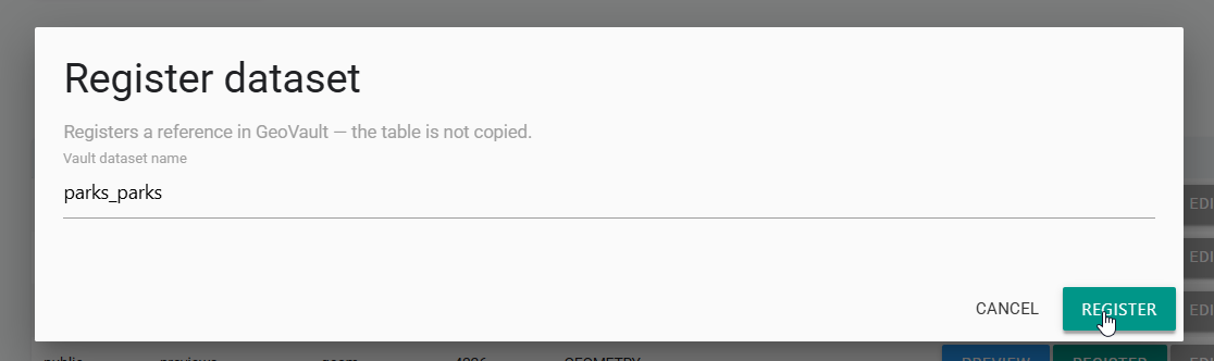
Caption: The Library name identifies the dataset in AcuGIS Cloud; it does not rename the source PostGIS table.
Registration is not a data copy
Registering creates a reference to the PostGIS table. Updates in the source database are reflected when the dataset is read again.
5. Verify the dataset
Open the registered dataset. Confirm that the features draw in the expected location, inspect several attributes, and verify that the page identifies the dataset as a PostGIS reference.
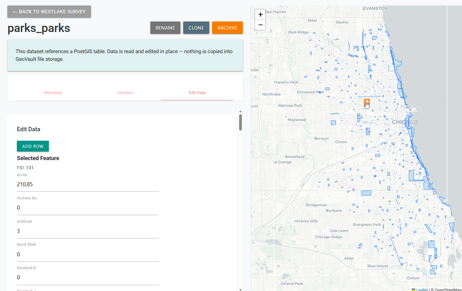
Caption: Correct geometry, map location, and attributes confirm that the source table was registered successfully.
If editing is intended, test a safe change using a non-production feature or an approved test table, then confirm the result in PostGIS.
Import with Wizard
Use Wizard when you want to discover tables, preview selected data, and choose the Library folder at the end of the workflow.
1. Add a PostGIS source
Open Administration, select Wizard, click Add Source, and choose Import from Database. Select an available Database Service and click Discover Tables.
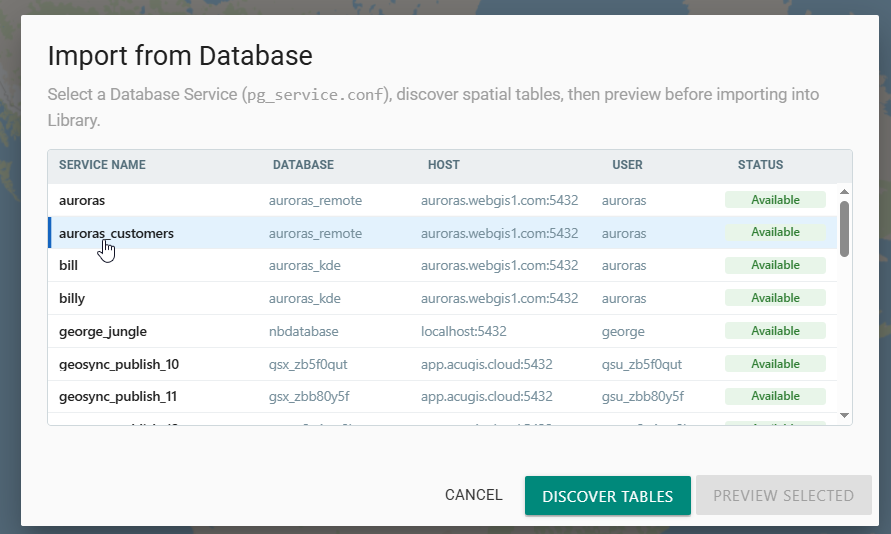
Caption: Wizard uses a configured Database Service to discover the spatial tables that its database role can access.
2. Select tables to preview
Search or filter the discovered tables as needed. Select one or more tables, then click Preview Selected.
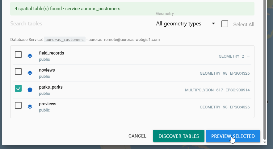
Caption: Geometry type, feature count, and EPSG information help identify the correct table before previewing it.
Select only what you need
Previewing a small set of tables makes the ingest session easier to review. Use the search and geometry-type filter when a database contains many spatial tables.
3. Review the preview and source details
Inspect the feature locations on the map. In Details, confirm the connection, database, service name, host, and selected table.
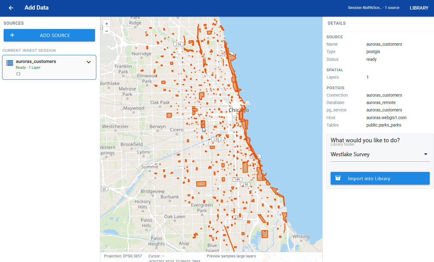
Caption: Preview the geometry and verify the source details before adding the reference to a Library folder.
Investigate an incorrect preview
Do not import a table whose features appear in the wrong location or whose source details are unexpected. Return to table selection and verify its SRID, geometry metadata, and Database Service.
4. Choose the Library folder and import
Under What would you like to do?, select the destination Library folder, then click Import into Library.
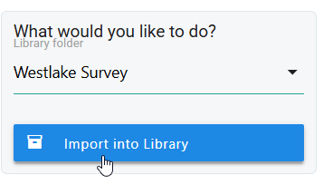
Caption: Wizard registers the selected PostGIS table in the chosen Library folder.
5. Verify the Library dataset
Open the destination folder and confirm that a dataset was created for each selected table. Click View to inspect its geometry and attributes.
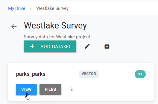
Caption: The registered PostGIS dataset is available from the selected Library folder.
For every selected table, verify the dataset name, feature location, attributes, and intended read or edit behavior.
Tips
Use dedicated database roles
Use a read-only role for display and analysis. Create a separate, narrowly scoped role for workflows that require editing so permissions are easy to audit and revoke.
Use stable dataset names
Choose a Library name that describes the data rather than its temporary environment or owner. The Library name can differ from the PostGIS table name and does not alter the source.
Index spatial and filter columns
Add an appropriate GiST or SP-GiST index to the geometry column and indexes to frequently filtered attributes. Indexes can substantially improve preview and map performance for large tables.
Verify every selected table
A Wizard session can include multiple tables with different geometry, CRS, or permission issues. Open and inspect each resulting dataset instead of treating one successful preview as verification of the entire session.
Coordinate schema changes
Renaming or dropping source columns, tables, schemas, or geometry fields can break registered datasets. Coordinate database migrations with dataset owners and test dependent maps after changes.
Common Problems
The Database Service is missing
The connection must be configured before import. Ask an administrator to create or restore the service, or follow Connect to PostGIS, then reopen the import workflow.
The Database Service is unavailable
Test the service connection and verify its host, port, database, credentials, SSL mode, firewall rules, and PostgreSQL pg_hba.conf access. A connection that works from a desktop may still be unreachable from AcuGIS Cloud.
No spatial tables are discovered
Confirm that the database role has USAGE on the schema and SELECT on the tables. Check that the tables have valid geometry columns registered in PostGIS metadata. Ordinary non-spatial tables are not included in this workflow.
The expected schema or table is missing
The selected service may point to the wrong database or use a role with limited access. Verify the service details, exact schema and table names, and the role's permissions.
Preview is empty or times out
Confirm that the table contains non-null geometries and that its geometry metadata is valid. For a large table, add a spatial index and review slow database queries, locks, network latency, and server resource usage.
Features appear in the wrong location
Compare the table's assigned SRID with the coordinates actually stored in its geometry column. Correct invalid source metadata or transform the data in PostGIS; do not assign a different CRS only to make the preview appear plausible.
Registration reports a name conflict
Choose a unique Vault dataset name or a different destination folder. Verify the existing dataset before renaming, replacing, or archiving anything.
The dataset opens but editing fails
Display requires read access, while editing also requires the relevant INSERT, UPDATE, or DELETE privileges and access to sequences, triggers, and related tables. Confirm that the table has a reliable feature identifier and grant only the missing permissions.
Source changes do not appear as expected
Reload the dataset and confirm that it still references the intended service, schema, and table. Database transactions may not be committed, and dependent maps or browser sessions may need to be refreshed.
A source table was changed accidentally
Stop further editing, notify the database owner, and use the database's backup, audit, or point-in-time recovery process as appropriate. Replace the connection with a read-only role before restoring user access.