Desktop
QGIS
- Layers
- Styles & labels
- Project file
 Atlas
Atlas
Web GIS Platform
Atlas brings together QGIS web publishing, spatial data management, reports and dashboards in one integrated web GIS environment.
Publish QGIS projects with QGIS Publisher through QGIS Server as a web map. Upload a .qgs, .qgz, or project zip from the web interface or from QGIS, then open the published map in the browser.
QGIS Publisher · GeoDrive · Reports · Dashboards
QGIS → Publisher → Web
Desktop
QGIS
QGIS Publisher
Upload & manage
QGIS web publishing, spatial data management, reports and dashboards in one web GIS environment.
Publish QGIS projects to the web with QGIS Server — from the desktop plugin, the web interface, or the CLI.
Organize, import and publish spatial datasets in a centralized workspace connected to your maps.
Run and share reports from live PostGIS data, maps and published GIS projects.
Present maps and operational GIS in interactive dashboards for review and reporting.
GIS teams already spend significant time building maps, configuring layers and organizing spatial data in QGIS. QGIS Publisher publishes that project into a web GIS environment served by QGIS Server.
Create and maintain maps, layers and project files with the desktop GIS tools your team already uses.
Upload the .qgs, .qgz, or a zip of the project and its data files from the web interface or the QGIS plugin.
Open the published project in the browser-based map viewer, with layers, legend, feature info and map tools.
Three stages: author the project in QGIS, publish it with QGIS Publisher, and deliver the map through the browser.
01
Create maps and spatial projects in QGIS. Package file-based layers with the project, or use PostGIS layers through a database connection.
02
Upload the project from the web interface, publish from QGIS with the AcuGIS Cloud Publisher plugin, or use the acugis maps publish CLI.
03
QGIS Server renders the published project as WMS/WFS. Users open the map in the OpenLayers viewer.
Publishing
Publish from QGIS or from the web. Update the same published map when the project changes.
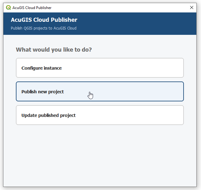
The AcuGIS Cloud Publisher plugin opens from QGIS: configure the instance, publish a new project, or update an existing one. The web interface accepts the same project files — .qgs, .qgz, or a zip of the project directory.
Use the current QGIS project directory, or upload a .qgs, .qgz, or zip from the web.
QGIS Publisher stores the project and serves it through QGIS Server. Open Map launches the viewer.
Replace the published bundle when the GIS work changes. Project ID and viewer URLs stay the same. A snapshot is taken before each update.
Built Around QGIS
QGIS is where GIS professionals build and maintain maps. QGIS Publisher extends that workflow to web delivery instead of forcing teams to recreate the project in a separate authoring environment.
Publish the project file itself — .qgs or .qgz — including a zip of the project folder and sidecar data files when layers are file-based.
The published project is passed to QGIS Server. Map output uses the project’s layers, QGIS symbology and labels rather than a separately restyled web map.
Projects that read PostgreSQL/PostGIS can use a Database Service so layers resolve after publish. File-based GeoPackage and shapefile layers travel with the zip.
Web GIS
The GIS team builds it in QGIS. Users open it on the web.
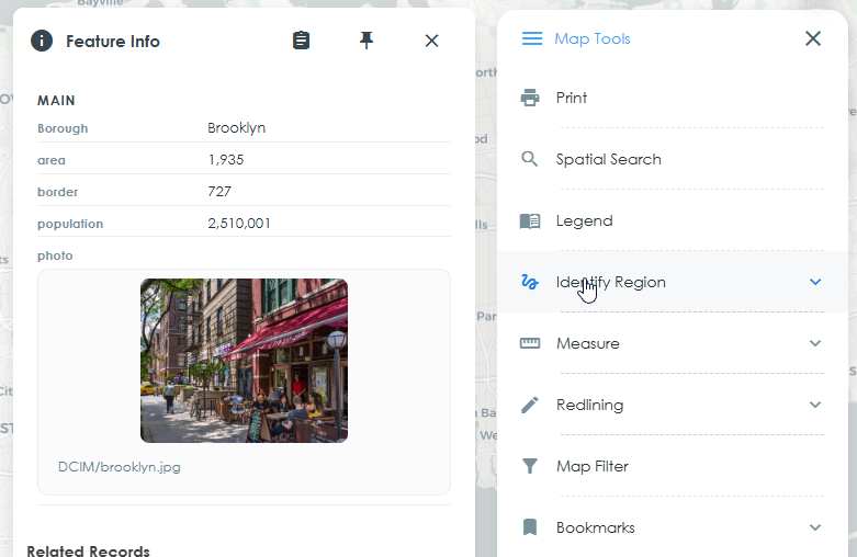
The published viewer is an OpenLayers map with the project’s layers. Click a feature for Feature Info — attributes, images and related records. Map Tools provide legend, identify, search, measure, print, bookmarks, filters and an attribute table.
Keep spatial data in open GIS infrastructure while using QGIS for authoring and QGIS Server for delivery.
Authoring
QGIS
Publishing
QGIS Publisher
Web mapping
QGIS Server
Spatial data
PostGIS
 QGIS
QGIS
 PostGIS
 PostgreSQL
QGIS Server
PostgreSQL
QGIS Server
Capabilities in QGIS Publisher for getting a QGIS project onto the web and keeping it current.
Publish QGIS projects as .qgs, .qgz, or a zip of the project and its data files. Publish from the web UI, the QGIS plugin, or the CLI.
File-based layers travel in the project package. PostGIS layers use a Database Service so the published project can reach PostgreSQL.
Browse published maps, open the viewer, set basemaps, choose legend/symbology mode, and configure Feature Info display.
Replace a published project in place. A snapshot is stored before each update so you can restore an earlier version.
QGIS Server exposes WMS and WFS. Choose Direct WMS, Cached WMS, or XYZ tiles for how the viewer requests the map.
Publishing is gated by service permissions. Projects can be opened from the viewer; new projects can be given public view access.
Published Map
A QGIS project in the browser: map, layers, Feature Info and Map Tools.
QGIS Publisher is for organizations that already work in QGIS and need those maps on the web. Atlas brings that publishing workflow together with GeoDrive, Reports and Dashboards.
Keep authoring maps in QGIS and publish them for broader use instead of rebuilding the same project for the web.
Publish operational, planning and public-facing GIS applications from existing QGIS projects.
Turn project GIS into a browser map that colleagues can open without installing QGIS.
Build web mapping around QGIS, PostGIS and QGIS Server rather than moving authoring into a proprietary web GIS.
Choose how you run Atlas. Self-hosting is a first-class option, not an add-on.
AcuGIS hosts and operates the Atlas environment, including QGIS Publisher, GeoDrive, Reports, Dashboards, QGIS Server and related infrastructure.
Run Atlas on infrastructure you control — your servers or your cloud account.
Atlas is available as a managed AcuGIS service and as self-hosted software. Choose the deployment that fits how you run GIS.
No separate edition is required. Start with managed hosting or deploy on your own servers.
Need Field GIS?
Atlas is the web GIS platform. Atlas Survey adds GeoSync so field collection, synchronization and web GIS work together.
Build in QGIS. Publish with QGIS Publisher. Deliver your maps through the browser.