Field
Field collection
GIS Synchronization
GeoSync connects your field and desktop GIS workflows with centralized spatial data and services.
GeoSync synchronizes mobile field data from QFieldCloud, Mergin Maps and ArcGIS Survey123 into PostGIS. Select a QGIS project, set a sync interval, and keep office GIS working from the same spatial database field teams update.
QFieldCloud · Mergin Maps · Survey123 · PostGIS · QGIS
Field to office GIS
Field
Field collection
GeoSync
Synchronization
Central GIS
PostGIS
Desktop
QGIS
Services
GeoServer
Spatial data is often collected and edited in more than one place. GeoSync connects those workflows so field teams, GIS professionals and centralized infrastructure can work from synchronized PostGIS data.
Collect data with QFieldCloud, Mergin Maps or ArcGIS Survey123. GeoSync writes field updates into PostGIS automatically.
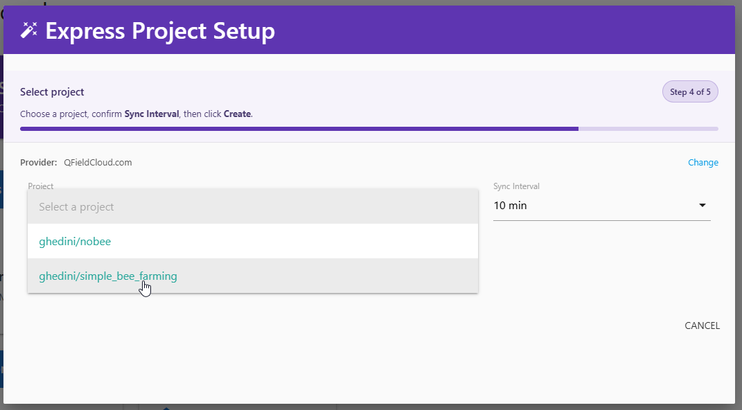
Select the QGIS project to synchronize. Desktop GIS teams continue working in QGIS against the central PostGIS database.
Create a new PostGIS database or connect an existing local or remote database as the authoritative store for synchronized layers.
Work with PostgreSQL, PostGIS, QGIS and GeoServer rather than moving the entire operation onto a proprietary GIS platform.
Three steps: choose a field provider, select a QGIS project, and start the sync service. GeoSync handles the rest on the interval you set.
Collect and update spatial data in QFieldCloud, Mergin Maps or Survey123 — hosted or self-hosted.
Connect the provider, choose the QGIS project, set the sync interval and start the service.
Field edits are written to a new or existing PostGIS database — local or remote.
Review, edit, analyze and manage the synchronized data in desktop GIS.
No extra plugins are required. Sync unlimited QGIS projects, monitor the service, and use PostGIS from QGIS, GeoServer, GeoNode, QWC2 or JDBC.
Field Workflows
Field Survey is a GeoSync workflow for collecting, synchronizing, reviewing and mapping spatial data — not a separate product edition.
Use an existing QFieldCloud, Mergin Maps or ArcGIS Survey123 account, or a dedicated field server. Add the QGIS project in GeoSync and field updates are synchronized to PostGIS. From there, review the data in QGIS and publish maps with GeoNode, QWC2 or Lizmap.
Field
Capture and update features in the field with QField, Mergin Maps or Survey123.
GeoSync
GeoSync pulls project updates on the interval you configure.
PostGIS
Authoritative layers live in PostGIS, available to office GIS tools.
QGIS
Open the data in QGIS, then share maps through your GIS stack.
QGIS Workflows
GeoSync is organized around QGIS projects, not a separate desktop environment.
Connect a field provider, select the QGIS project to synchronize, and GeoSync keeps that project’s data in PostGIS. GIS teams continue using QGIS for review, editing and analysis instead of copying datasets by hand.
GeoSync is designed around open geospatial technologies and workflows, helping organizations connect field and desktop GIS without moving their entire operation into a proprietary GIS platform.
 PostgreSQL
 PostGIS
 QGIS
QGIS
 GeoServer
QFieldCloud Mergin Maps ArcGIS Survey123 Self-hosted providers
Run GeoSync as a managed AcuGIS service, or deploy it on infrastructure you control. Self-hosting is a first-class option, not an enterprise-only add-on.
AcuGIS operates and maintains the GeoSync environment, including PostgreSQL, PostGIS, SSL and hosting in your choice of locations.
Get StartedDeploy GeoSync on infrastructure you control — your own servers or your AWS, Azure, Google Cloud or DigitalOcean environment.
On-Premise OptionsWatch GeoSync synchronize field GIS workflows, then explore the Field Survey workflow on this page.
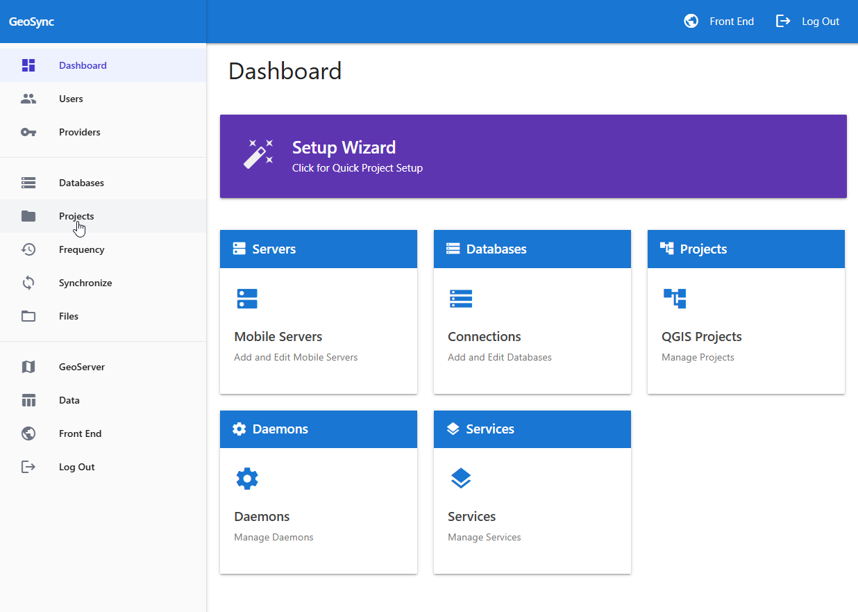
See the GeoSync interface and the path from field provider to PostGIS.
QFieldCloud · Mergin Maps · Survey123 · PostGIS
View Demo →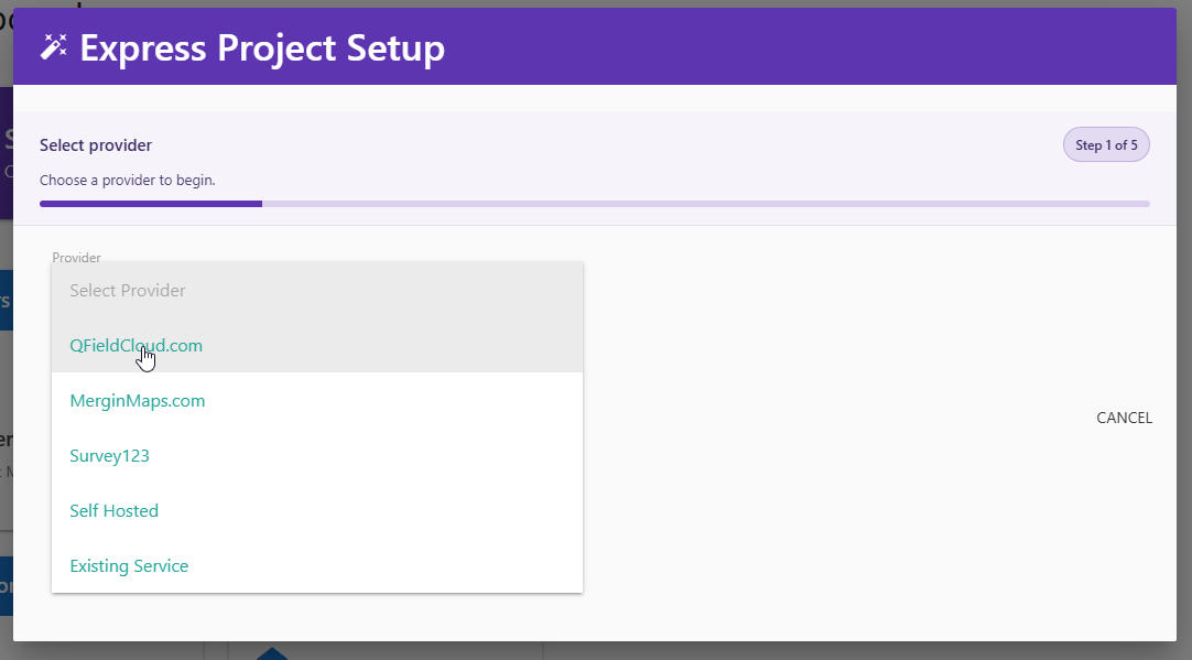
A complete field-to-office workflow: collect, synchronize, centralize and review.
Field collection · GeoSync · PostGIS · QGIS
View Workflow →Managed GeoSync plans include GeoSync, PostgreSQL, PostGIS, SSL and domain mapping. Unlimited users. Scale when you need to.
$39/mo
$390/yr with annual billing
$59/mo
$590/yr with annual billing
$99/mo
$990/yr with annual billing
Annual billing includes two months free. Self-hosted and on-premise deployment is available separately.
Web GIS Platform
Atlas is the web GIS platform, with QGIS Publisher, GeoDrive, Reports and Dashboards. GeoSync remains a standalone product for field, desktop and server synchronization.
Bring field collection, centralized spatial data and QGIS workflows together with GeoSync.